
Wonokromo
Wonokromo
Kecamatan Wonokromo | |
|---|---|
 Graha Bumiputera Wonokromo | |
 Map of Wonokromo in Surabaya | |
 Interactive map outlining Wonokromo | |
| Coordinates: 7°18′01″S 112°44′15″E / 7.30032°S 112.737509°E | |
| Country | |
| Province | East Java |
| City | Surabaya |
| Area | |
| • Total | 8.47 km2 (3.27 sq mi) |
| BPS[1] | |
| Population (2014) | |
| • Total | 198,613 |
| • Density | 23,000/km2 (61,000/sq mi) |
| Time zone | GMT +7 |
Wonokromo is a district in Surabaya, Indonesia. The Wonokromo railway station serves the area. The Kalimas River originally turned north and empties into the Tanjung Perak and Kali Jagir, a manmade branch of the river that connects east to the sea and includes a dam built by the Dutch. The area is also home to DTC (Darmo Trade Center) formerly the Wonokromo Market.[2]
Administrative divisions
Wonokromo is divided into 6 administrative villages:
- Ngagel
- Ngagelrejo
- Darmo
- Sawunggaling
- Wonokromo
- Jagir
Gallery
-
 Wonokromo Market circa 1930s
 -
 Wonokromo Lock circa 1930s
 -
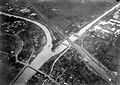 Kali Jagir, Wonokromo aerial circa 1920s
 -
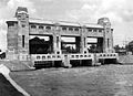
 Wonokromo Lock
 -
 Bandjirsluis
 -
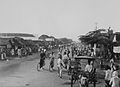
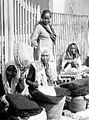 Women at the Wonokromo Market
 -
 Wonokromo Bridge
 -
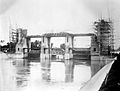 Wonokromo lock construction early 1920s
 -
 Wonokromo Market


_Soerabaja_Oost-Java_TMnr_10007868.jpg)

_te_Wonokromo_Surabaya_Java_TMnr_10002411.jpg)


References
- ^ "Badan Pusat Statistik". surabayakota.bps.go.id (in Indonesian). Retrieved 2018-11-30.
- ^ "Kecamatan Wonokromo | Bagian Administrasi Pemerintahan dan Otonomi Daerah Kota Surabaya". pemerintahan.surabaya.go.id (in Indonesian). Retrieved 2018-11-30.