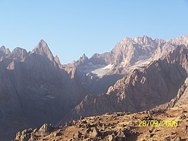
Cilo Dağı
Appearance
| Cilo Dağı | |
|---|---|
 Cilo Dağı | |
| Highest point | |
| Elevation | 4,116 m (13,504 ft) |
| Geography | |
| Location | Yüksekova, Hakkâri Province, Turkey |
| Parent range | Taurus Mountains |
Cilo Dağı ("mount of Cilo" in Turkish), 4116 m high, [1][2] is the third highest mountain in Turkey. The mountain is located in the Hakkâri Dağları chain, located in the eastern Taurus, in the district of Yüksekova of the Hakkâri Province. Cilo Dağı is part of the 30 km long Cilo mountain range.[3] The Uludoruk (4135 m), located in the immediate vicinity (4 km away), is the second highest mountain in Turkey. In 1984, the area was closed to civilians. It was not until 2002 that a team of mountaineers was authorized to climb again the Cilo mountains.[4]
Notes
- ^ The New Encyclopaedia Britannica: Macropaedia. University of Michigan p. 920
- ^ Brockhaus, Enzyklopädie in 30 Bänden, Vol. 28. Mannheim 2006, p. 117, s.v. Türkei.
- ^ www.tuerkei-kultur-info.de
- ^ Hürriyet, 28. September 2002

