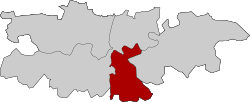
Santa Bárbara (Toledo)
Appearance
Santa Bárbara | |
|---|---|
City district | |
 | |
 | |
| Country | Spain |
| Region | Castilla–La Mancha |
| Municipality | Toledo |
| Population (2018) | |
• Total | 7,888 |
Santa Bárbara is a district (number 2) and neighborhood of Toledo, Spain.
Through the Cuesta de San Servando, the urbanised area is connected to the historic centre[1] (at the opposite bank of the Tagus) as well as to the Castle of San Servando, the Toledo Infantry Academy and the Provincial Hospital of Toledo,[1] which are all located within the district limits. It has its own football turf, located in the east of the urbanised area.[2] As of 1 January 2018, the district has a population of 7,888 inhabitants (the district consists solely of the namesake neighborhood).[3]
References
[edit]- ^ a b "Santa Bárbara y la Academia de Infantería, conectadas a finales de marzo". ABC. 20 February 2019.
- ^ "Toledo revitaliza su campo de fútbol de Santa Bárbara". Mondo. 16 November 2016.
- ^ "Evolución de la población por barrios y distritos". Ayuntamiento de Toledo. Retrieved 23 March 2020.
