Volnaya (river)
Appearance
| Volnaya | |
|---|---|
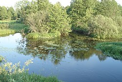
 The Volnaya near the village of Stepanovka, Orekhovo-Zuyevsky District | |
 | |
| Native name | Вольная Error {{native name checker}}: parameter value is malformed (help) |
| Location | |
| Country | Russia |
| Physical characteristics | |
| Mouth | Nerskaya |
• coordinates | 55°35′17″N 38°56′43″E / 55.5881°N 38.9454°E |
| Length | 27 km (17 mi) |
| Basin size | 143 km2 (55 sq mi) |
| Basin features | |
| Progression | Nerskaya→ Moskva→ Oka→ Volga→ Caspian Sea |
The Volnaya (Template:Lang-ru) is a river in Moscow Oblast, Russia. It is a left tributary of the Nerskaya (Moskva tributary). It is 27 kilometres (17 mi) long, and has a drainage basin of 143 square kilometres (55 sq mi).[1]
References
- ^ «Река Вольная», Russian State Water Registry
- Russian: Вагнер Б. Б. Реки и озера Подмосковья. — М.: Вече, 2007. — С. 51–52. ISBN 5-9533-1885-5.
