Bitagron
Appearance
Witagron | |
|---|---|
| Coordinates: 5°10′N 56°06′W / 5.167°N 56.100°W | |
| Country | |
| District | Sipaliwini District |
| Resort (municipality) | Boven Coppename |
Witagron is a Kwinti village in Suriname on the Coppename River at the crossing of the Southern East-West Link from Paramaribo to Apoera in West-Suriname.[1]
In the local language Witagron means 'Land of my forefathers'.[2]
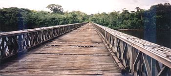
In 1975-76 a Bailey bridge was built across the river to replace the pontoon ferry.

Healthcare
Witagron is home to a Medische Zending healthcare centre.[3]
Notes
- ^ Migge & Léglise 2013, p. 83.
- ^ "Beschrijving Zuid Oost-West verbinding" (PDF). Planning Office Suriname (in Dutch). Retrieved 27 May 2020.
- ^ "Zorggebied". Medische Zending.sr (in Dutch). Retrieved 27 May 2020.

