Kekerengu Fault


The Kekerengu Fault is an active dextral (right lateral) strike-slip fault in the northeastern part of South Island, New Zealand. It is closely associated with the Hope Fault and Jordan Thrust at its south-easternmost edge and likely joins with the Clarence Fault to form the Wairarapa Fault offshore in Cook Strait.[1][2]
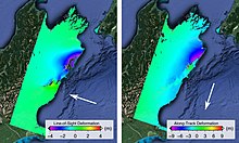
Early investigations immediately following the 14 November 2016 Kaikōura earthquake indicate that up to 10 m (33 ft) of motion may have occurred on the Kekerengu Fault during the 7.8 magnitude quake.[3] During this earthquake the offshore continuation of the Kekerengu Fault to the north east, known as the Needles Fault, ruptured as well. NIWA marine geologist Dr Philip Barnes said the length of the Kekerengu–Needles Fault rupture may extend for about 70 km (43 mi), consisting of 36 km (22 mi) on land and 34 km (21 mi) under the sea.[4]
References
- ^ Zachariasen, Judith; Berryman, Kelvin; Langridge, Robert; Prentice, Caro; Rymer, Michael; Stirling, Mark; Villamor, Pilar (2006). "Timing of late Holocene surface rupture of the Wairau Fault, Marlborough, New Zealand". New Zealand Journal of Geology and Geophysics. 49 (1): 159–174. doi:10.1080/00288306.2006.9515156.
- ^ Lensen, G.J. (1958). "Note on fault correlations across Cook Strait". New Zealand Journal of Geology and Geophysics. 1 (2): 263–268. doi:10.1080/00288306.1958.10423182.
- ^ McBride, Sue (14 November 2016). "M7.8 Kaikoura Earthquake: Latest updates".
- ^ "Huge fault rupture stretches 34km offshore from Kaikoura". Stuff. 23 November 2016. Retrieved 24 November 2016.
