
Port Dalhousie
This article includes a list of general references, but it lacks sufficient corresponding inline citations. (November 2009) |


Port Dalhousie /dəˈluːzi/ is a community in St. Catharines, Ontario, Canada. It is known for its waterfront appeal. It is also home to the Royal Canadian Henley Regatta and is historically significant as the terminus for the first three (19th century) routes of the Welland Canal, built in 1820, 1845 and 1889.[1]
Activities
The city's most popular beach, on the shore of Lake Ontario, is located in Port Dalhousie at historic Lakeside Park. Popular activities that take place at the beach are stand up paddle boarding, swimming, kayaking & beach volleyball. The park is home to the Lakeside Park Carousel which was carved by Charles I. D. Looff in 1905 and brought to St. Catharines in 1921. It continues to provide amusement for young and old alike, at just 5 cents a ride. The Royal Canadian Henley Regatta, on Martindale Pond, has been happening for "almost 100 years".[2]
Etymology
Port Dalhousie is named for George Ramsay, 9th Earl of Dalhousie, Governor General of British North America. Dalhousie also gave his name to Dalhousie University in Halifax, Nova Scotia, and to the town of Dalhousie, New Brunswick.
Dalhousie pronounced his name 'dal-HOW-zee' during his time. All of his namesakes carry this pronunciation except Port Dalhousie, which is pronounced 'duh-LOO-zee'. It is said that this is a result of the accent of the Scottish sailors and shipbuilders who frequented the Port's establishments (Dalhousie, himself a Scot, used the more upper class English-sounding pronunciation).
Climate
| Climate data for Port Dalhousie (1981–2010, extremes 1957–1996) | |||||||||||||
|---|---|---|---|---|---|---|---|---|---|---|---|---|---|
| Month | Jan | Feb | Mar | Apr | May | Jun | Jul | Aug | Sep | Oct | Nov | Dec | Year |
| Record high °C (°F) | 18.5 (65.3) |
15.0 (59.0) |
24.5 (76.1) |
30.0 (86.0) |
33.3 (91.9) |
35.0 (95.0) |
37.0 (98.6) |
36.0 (96.8) |
35.6 (96.1) |
29.4 (84.9) |
26.7 (80.1) |
22.0 (71.6) |
37.0 (98.6) |
| Mean daily maximum °C (°F) | −0.2 (31.6) |
0.5 (32.9) |
5.1 (41.2) |
12.0 (53.6) |
18.9 (66.0) |
24.0 (75.2) |
27.1 (80.8) |
26.0 (78.8) |
21.1 (70.0) |
14.7 (58.5) |
8.5 (47.3) |
2.4 (36.3) |
13.3 (55.9) |
| Daily mean °C (°F) | −3.4 (25.9) |
−2.9 (26.8) |
1.2 (34.2) |
7.4 (45.3) |
13.5 (56.3) |
19.0 (66.2) |
22.4 (72.3) |
21.4 (70.5) |
17.0 (62.6) |
10.8 (51.4) |
5.2 (41.4) |
−0.6 (30.9) |
9.3 (48.7) |
| Mean daily minimum °C (°F) | −6.6 (20.1) |
−6.3 (20.7) |
−2.8 (27.0) |
2.9 (37.2) |
8.2 (46.8) |
14.0 (57.2) |
17.6 (63.7) |
16.8 (62.2) |
12.8 (55.0) |
6.9 (44.4) |
1.9 (35.4) |
−3.5 (25.7) |
5.1 (41.2) |
| Record low °C (°F) | −24.5 (−12.1) |
−24.5 (−12.1) |
−17.0 (1.4) |
−8.5 (16.7) |
−2.8 (27.0) |
2.2 (36.0) |
6.7 (44.1) |
3.9 (39.0) |
0.0 (32.0) |
−6.1 (21.0) |
−13.3 (8.1) |
−23.5 (−10.3) |
−24.5 (−12.1) |
| Average precipitation mm (inches) | 60.5 (2.38) |
64.2 (2.53) |
63.8 (2.51) |
84.1 (3.31) |
84.5 (3.33) |
83.9 (3.30) |
84.7 (3.33) |
74.0 (2.91) |
95.4 (3.76) |
76.6 (3.02) |
95.0 (3.74) |
78.4 (3.09) |
945.1 (37.21) |
| Average rainfall mm (inches) | 26.7 (1.05) |
30.6 (1.20) |
46.1 (1.81) |
79.3 (3.12) |
84.0 (3.31) |
83.9 (3.30) |
84.7 (3.33) |
74.0 (2.91) |
95.4 (3.76) |
76.6 (3.02) |
89.8 (3.54) |
50.6 (1.99) |
821.6 (32.35) |
| Average snowfall cm (inches) | 33.8 (13.3) |
33.6 (13.2) |
17.7 (7.0) |
4.8 (1.9) |
0.5 (0.2) |
0.0 (0.0) |
0.0 (0.0) |
0.0 (0.0) |
0.0 (0.0) |
0.0 (0.0) |
5.2 (2.0) |
27.9 (11.0) |
123.4 (48.6) |
| Average precipitation days (≥ 0.2 mm) | 14.8 | 12.8 | 13.5 | 14.2 | 12.0 | 11.1 | 10.4 | 10.5 | 12.1 | 12.1 | 15.1 | 14.1 | 152.6 |
| Average rainy days (≥ 0.2 mm) | 6.3 | 6.3 | 9.9 | 13.5 | 11.9 | 11.1 | 10.4 | 10.5 | 12.1 | 12.1 | 14.1 | 9.1 | 127.3 |
| Average snowy days (≥ 0.2 cm) | 9.5 | 7.9 | 4.6 | 1.3 | 0.13 | 0.0 | 0.0 | 0.0 | 0.0 | 0.0 | 1.3 | 6.8 | 31.5 |
| Source: Environment Canada[3] | |||||||||||||
Gallery
-
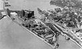
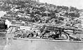 Aerial view, 1920
 -
 Aerial view, 1920
 -
 Aerial view, 1920
 -
 Port Dalhousie, 2018
 -
 A memorial in the town to the local soldiers who died in the First and Second World Wars, and in the Korean War.


References
- ^ St. Catharines Archived 2014-12-20 at the Wayback Machine
- ^ St.Catharines Archived 2014-12-20 at the Wayback Machine
- ^ "Port Dalhousie". Canadian Climate Normals 1981–2010 (in English and French). Environment Canada. Retrieved April 3, 2016.
External links
- The Welland Canals Advocate
- Port Dalhousie's Only Online Community Journal
- Dalhousie Peer Magazine
- Port Dalhousie Official BIA website
- Port Dalhousie walking tour
- Images from the Historic Niagara Digital Collections at the Niagara Falls Public Library
- HistoricPlaces.ca - Port Dalhousie