South Aegean Volcanic Arc

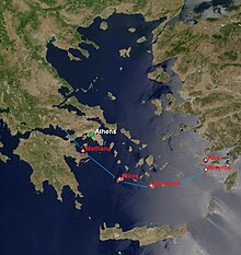
The South Aegean Volcanic Arc is a volcanic arc (chain of volcanoes) in the South Aegean Sea formed by plate tectonics as a consequence of the subduction of the African plate tectonic plate beneath the Eurasian plate. The southern Aegean is one of the most rapidly deforming regions of the Himalayan-Alpine mountain belt. It is approximately 450 km long and 20 km to 40 km wide and runs from the Isthmus of Corinth on the Greek mainland to the Bodrum peninsula on the Turkish mainland.[1]
The active portion of the South Aegean Arc comprises a number of dormant and historically active volcanoes, including Sousaki, Aegina, Methana, Milos, Santorini and Kolumbo, Kos, Nisyros and Yali, and Akyarlar. Of these, only Santorini, Kolumbo and Nisyros have either erupted or shown any significant evidence of unrest during the past 100 years.[2]
One of the most noted volcanic eruptions from this arc occurred on the island of Santorini in the second millennium BC; during this eruption the Bronze Age city of Akrotiri was destroyed, with archaeological remains becoming well preserved under the volcanic ash.[3]
See also
References
- ^ The South Aegean Active Volcanic Arc: Present Knowledge and Future Perspectives By Michaēl Phytikas, Georges E. Vougioukalakis, 2005, Elsevier, 398 pages, ISBN 0-444-52046-5
- ^ Chapter 15 (Volcanoes), The Physical Geography of the Mediterranean, ed. Jamie C Woodward, Oxford University Press, 2009, ISBN 0-19-926803-7
- ^ C. Michael Hogan, Akrotiri, The Modern Antiquarian (2007)
