
Werpe
Werpe | |
|---|---|
 | |
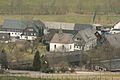
Location of Werpe  | |
 Werpe  Werpe | |
| Coordinates: 51°9′20″N 8°15′4″E / 51.15556°N 8.25111°E | |
| Country | Germany |
| State | North Rhine-Westphalia |
| Admin. region | Arnsberg |
| District | Hochsauerlandkreis |
| Town | Schmallenberg |
| Population (2018-12-31) | |
| • Total | 212 |
| Time zone | UTC+01:00 (CET) |
| • Summer (DST) | UTC+02:00 (CEST) |
Werpe is a locality in the municipality Schmallenberg in the district Hochsauerlandkreis in North Rhine-Westphalia, Germany.
The Werpe has 212 inhabitants[1] and lies in the west of the municipality of Schmallenberg at a height of around 430 m. The river Wehrsiepen flows through the village.
Werpe borders on the villages of Harbecke, Felbecke, Wormbach, Schmallenberg and Fleckenberg. Schmallenberg’s aerodrome (Motorsport- und Segelflugplatz Rennefeld)[2] is between the villages of Werpe and Wormbach. In the village centre the Landesstraße 737 meets the Kreisstraße 25.
Werpe was first mentioned in 1221 in a document. The village used to belong to the municipality of Wormbach in Amt Schmallenberg until the end of 1974.
Gallery
-
 „Werpe“ 1645 - Westphalia Ducatus (Duchy of Westphalia)
 -
 Chapel in Werpe


References
- ^ Schmallenberg.de: Inhabitants (in German)
- ^ Rennefeld.de (in German)
Wikimedia Commons has media related to Werpe.
| International | |
|---|---|
| National | |