
Kranichfeld
Kranichfeld | |
|---|---|
 Coat of arms | |
Location of Kranichfeld within Weimarer Land district 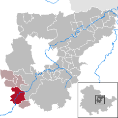 | |
 Kranichfeld  Kranichfeld | |
| Coordinates: 50°51′0″N 11°12′0″E / 50.85000°N 11.20000°E | |
| Country | Germany |
| State | Thuringia |
| District | Weimarer Land |
| Municipal assoc. | Kranichfeld |
| Subdivisions | 3 |
| Government | |
| • Mayor | Wolf-Ludger Schlotzhauer (FDP) |
| Area | |
| • Total | 23.08 km2 (8.91 sq mi) |
| Elevation | 301 m (988 ft) |
| Population (2022-12-31)[1] | |
| • Total | 3,313 |
| • Density | 140/km2 (370/sq mi) |
| Time zone | UTC+01:00 (CET) |
| • Summer (DST) | UTC+02:00 (CEST) |
| Postal codes | 99446–99448 |
| Dialling codes | 036450 |
| Vehicle registration | AP |
| Website | www.kranichfeld.de |
Kranichfeld is a town in the Weimarer Land district, in Thuringia. It is situated on the river Ilm, 18 km southeast of Erfurt, and 16 km southwest of Weimar.
History
Within the German Empire (1871-1918), Kranichfeld was part of the Grand Duchy of Saxe-Weimar-Eisenach.
References

| International | |
|---|---|
| National | |
| Geographic | |
This Weimarer Land location article is a stub. You can help Wikipedia by expanding it. |