Podbrezová
Podbrezová | |
|---|---|
Village | |
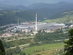
 View on industrial quarter | |
| Coordinates: 48°49′00″N 19°32′00″E / 48.81667°N 19.53333°E | |
| Country | Slovakia |
| Region | Banská Bystrica |
| District | Brezno |
| Area | |
| • Total | 18.565 km2 (7.168 sq mi) |
| Elevation | 470 m (1,540 ft) |
| Population (2004) | |
| • Total | 4,171 |
| • Density | 220/km2 (580/sq mi) |
| Postal code | 97681 |
| Area code | +421-48 |
| Car plate | BR |
| Source:[1] | |
Podbrezová (Slovak pronunciation: [ˈpɔdbɾɛzɔʋaː]) is a large village and municipality in Brezno District, in the Banská Bystrica Region of central Slovakia, around 10 km west of the district seat town, Brezno.
History
The village is actually made of six former independent settlements, which were grouped in the 19th century around a new mill - the Hron iron works.
Sport
Football
Podbrezová has a football club FO ŽP Šport Podbrezová which currently plays in the Fortuna Liga. In the 2013–2014 season, Podbrezová finished first in this league and will therefore promote to the highest Slovak league, the Slovak Super Liga for the 2014–2015 season. This is the first time in the club's existence that they will play in this league. Home games are played in the ZELPO Arena, located in Podbrezová.
References
- ^ "Municipal Statistics". Statistical Office of the Slovak republic. Archived from the original on 2007-04-27. Retrieved 2007-05-03.
External links
- Municipal website (in Slovak)

