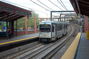
Station Square station
This article needs additional citations for verification. (August 2018) |
Station Square | |||||||||||||
|---|---|---|---|---|---|---|---|---|---|---|---|---|---|
 | |||||||||||||
| General information | |||||||||||||
| Location | Smithfield Street Bridge at Carson Street Pittsburgh, Pennsylvania | ||||||||||||
| Coordinates | 40°25′54″N 80°00′12″W / 40.4317°N 80.0033°W | ||||||||||||
| Owned by | Port Authority | ||||||||||||
| Platforms | 2 side platforms | ||||||||||||
| Tracks | 2 | ||||||||||||
| Construction | |||||||||||||
| Structure type | at-grade | ||||||||||||
| Parking | 160 spaces | ||||||||||||
| Accessible | Yes | ||||||||||||
| History | |||||||||||||
| Opened | 1985 | ||||||||||||
| Passengers | |||||||||||||
| 2018 | 1,304[1] (weekday boardings) | ||||||||||||
| Services | |||||||||||||
|
Lua error in Module:Adjacent_stations at line 237: Unknown line "Blue". | |||||||||||||
| |||||||||||||
Station Square is a transit station on the Port Authority of Allegheny County's light rail network. It is the last Transit station on the south side of the Monongahela River.
This station is named for the nearby Station Square mixed-use development and opened in 1985. Many South Hills residents access the facility using light rail service, and employees at the adjacent major office park, which includes the headquarters of WESCO International are also major beneficiaries of the stop. Several thousand commuters each weekday also rely on this stop as a park-and-ride station, using either a 160 space Port Authority lot or the privately owned garage in Station Square.
The station's close proximity to the Monongahela Incline, South Busway, Carson and Smithfield Streets, and the large parking facilities and boat docks of the Gateway Clipper Fleet at Station Square add to the station's inter-modal transportation value.
History
This station is named for the nearby mixed-use development Station Square. The station was not originally planned to be built; instead, the light rail system was to bypass the newly created development because officials felt that there would not be enough ridership demand to justify the station. Active lobbying by Arthur P. Ziegler, Jr., President of Pittsburgh History and Landmarks Foundation, and developer of Station Square ensured that the station was constructed. Over 3 million tourists visit Station Square each year.
Originally designed and built by Daniel Sifer, the station encompasses railings rescued by Pittsburgh History and Landmarks Foundation from the Brady Street Bridge, which was demolished in 1978. In the late 1990s, DRS Architects renovated the station and provided architectural details in glass that reflected the design in the Brady Street Bridge railings.
On August 5, 2018, a Norfolk Southern freight train running on the Mon Line derailed east of Station Square station and blocked the tracks, forcing service to be suspended.[2] The derailment caused no injuries, as it had occurred two minutes after a T light rail train had left the station.[3] The derailed cars fell onto the tracks and damaged 1,600 feet (490 m) of light rail tracks, 4,000 feet (1,200 m) of overhead electrical wires, and some concrete on the Panhandle Bridge.[4] During cleanup and inspections of the area, the Mount Washington Transit Tunnel was closed and trains were rerouted via the former Brown Line through Allentown.[5] The outbound tracks were opened on August 23,[6] while inbound service resumed on August 25 after repairs were completed.[7] A preliminary report by the Federal Railroad Administration's investigation team found that a fractured track caused the derailment.[8] Norfolk Southern filed a lawsuit in December 2018 seeking $1.1 million in reimbursements from the city for the incident, claiming that they had neglected to maintain the hillside.[9]
Connecting services
- Y45 Baldwin Manor Flyer
- Y49 Prospect Park Flyer
- Y46 Elizabeth Flyer
- 39 Brookline
- 41 Bower Hill
- 44 Knoxville
- 48 Arlington Heights
- 51 Carrick
- 51L Carrick Limited
- Y1 Large Flyer
- MMVTA Route A
- FACT Commuter Route
- Monongahela Incline
See also
References
- ^ "System Map Winter 2018". Port Authority.
{{cite web}}: CS1 maint: url-status (link) - ^ Conroy, Anthony; Rotstein, Gary; Kirkland, Kevin (August 5, 2018). "'We came very close to having a tragedy:' Freight cars derail above Station Square T stop". Pittsburgh Post-Gazette. Retrieved August 9, 2018.
- ^ Bradbury, Shelly; Smeltz, Adam (August 6, 2018). "How close is close? Derailed freight train was minutes from striking Port Authority T, agency says". Pittsburgh Post-Gazette. Retrieved August 9, 2018.
- ^ Blazina, Ed (August 9, 2018). "Port Authority finds 'extensive damage' to its tracks after Norfolk Southern derailment". Pittsburgh Post-Gazette. Retrieved August 9, 2018.
- ^ Lindstrom, Natasha (August 6, 2018). "Train derailment slows commute via Pittsburgh's rails, roads: 5 things to know Tuesday". Pittsburgh Tribune-Review. Retrieved August 9, 2018.
- ^ "Port Authority To Resume Inbound T Service Through Station Square Saturday". KDKA. August 24, 2018. Retrieved August 24, 2018.
- ^ "Station Square T stop reopens after freight train derailment". Almanac. August 27, 2018. Retrieved January 8, 2019.
- ^ Blazina, Ed (November 21, 2018). "Broken track caused Norfolk Southern freight train derailment at Station Square". Pittsburgh Post-Gazette. Retrieved January 8, 2019.
- ^ Blazina, Ed (December 20, 2018). "Norfolk Southern sues Pittsburgh seeking $1.1M in costs from 2016 landslide above Station Square". Pittsburgh Post-Gazette. Retrieved January 8, 2019.
