Naaldwijk
Naaldwijk | |
|---|---|
Town | |
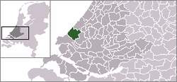
 The village (dark green) and the statistical district (light green) of Naaldwijk in the municipality of Westland. | |
 | |
| Coordinates: 51°59′35″N 4°12′18″E / 51.99306°N 4.20500°E | |
| Country | Netherlands |
| Province | Zuid-Holland |
| Municipality | Westland |
| Population (January 2011) | 18,858 |
| Postal code | 2670-2673 |
| Dialing code | 0174 |
| Major roads | N213 |
Naaldwijk (Dutch pronunciation: [ˈnaːltʋɛi̯k]) is a town in the Dutch province of South Holland. It is a part of the municipality of Westland, and lies about 10 km southwest of The Hague.
Naaldwijk lies in the heart of Westland. The largest economic sector is greenhouse horticulture. The largest flower auction site in the world, operated by FloraHolland, can be found in the nearby village of Honselersdijk.
Naaldwijk was previously a municipality in its own right, covering an area of 25.33 km² (of which 0.23 km² water). It included the towns Honselersdijk and Maasdijk.
On 1 January 2004 the municipality of Naaldwijk was merged with the neighbouring municipalities De Lier, 's-Gravenzande, Monster, and Wateringen to create the municipality of Westland. Naaldwijk is now the administrative capital of Westland.
The village of "Naaldwijk" has a population of around 15,440.[1] The statistical area "Naaldwijk", which also can include the surrounding countryside, has a population of around 17,370.[1]
Areas and neighbourhoods
- Galgenblok
- Opstal
- Woerdblok (Waterwijk, Zandstrand, Zandheuvel, Waterrijk)
- Pijletuinen
- Kruisbroek
- Geestcomplex
- Hoogeland
- Floriëndaal
Image gallery
-
Naaldwijk in 1867
-
Welcome sign
-
De Oude Kerk
-
Sint Adrianus church
-
Heilige geesthof
-
Watertower
-
Monument voor de Gevallenen by Mari Andriessen
References
- ^ a b Statistics Netherlands (CBS), Statline: Kerncijfers wijken en buurten 2003-2005. As of 1 January 2005.
External links


