
Batticaloa Lighthouse
 Batticaloa Lighthouse | |
 | |
| Location | Batticaloa Eastern Province Sri Lanka |
|---|---|
| Coordinates | 7°45′17.7″N 81°41′07.6″E / 7.754917°N 81.685444°E |
| Tower | |
| Constructed | 1913 |
| Construction | masonry tower |
| Height | 28 metres (92 ft) |
| Shape | tapered cylindrical tower with balcony and lantern on a stone basement |
| Markings | white tower and lantern |
| Power source | mains electricity |
| Operator | Sri Lanka Ports Authority[1] |
| Light | |
| Focal height | 27 metres (89 ft) |
| Light source | mains power |
| Range | 10 nmi (19 km; 12 mi) |
| Characteristic | Fl W 3s. |
Batticaloa Lighthouse is a lighthouse in Sri Lanka, situated near the estuary in Palameenmadu. It was built in 1913[2] and is 28 meters high.
Location
Batticaloa's lighthouse is around 5 km from Batticaloa city, on Bar Road. You can access to it by taking Lake Road (also called Munich Vittoria Friendship Road) near Kallady Bridge and proceeding along Sinna Uppodai Lagoon for around 4 km. It is a very nice area for cycling or walking.
Gallery
-
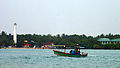
 Batticaloa light house from Batticaloa lagoon
 -
 Batticaloa Lighthiuse from Batticaloa Beeach site
 -
 Batticaloa Lighthouse Evening Time
 -
 Ruins of old Batticaloa Lighthouse, which was built by British Ceylon
 -
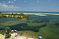 View from the top of the lighthouse


.jpg)
See also
References
- ^ Batticaloa (Mattuwaran) The Lighthouse Directory. University of North Carolina at Chapel Hill. Retrieved April 1, 2016
- ^ "Batticaloa Lighthouse". Retrieved February 13, 2013.
External links
- Sri Lanka Ports Authority
- Batticaloa Lighthouse amazinglanka.com
- Lighthouses of Sri Lanka
Wikimedia Commons has media related to Batticaloa Lighthouse.
This lighthouse-related article is a stub. You can help Wikipedia by expanding it. |