
Oulton, West Yorkshire

Oulton is a village in the City of Leeds metropolitan borough, West Yorkshire, England, between Leeds and Wakefield. It is at the junction of the A639 and A642 roads. Though now adjoining the village of Woodlesford, it was once quite separate.[citation needed]
The village formed part of the Rothwell Urban District until its merger into the City of Leeds Metropolitan District in 1974 and today sits in the Rothwell ward of Leeds City Council. It is also in the Elmet and Rothwell parliamentary constituency.
Oulton Hall was built in 1850 and is now a hotel and conference centre.[citation needed]
Notable and former residents
- Oulton's most famous son [according to whom?] is Richard Bentley who became Master of Trinity College, Cambridge.
- The cricketer and Anglican clergyman Henry Bell was born in Oulton.
-
 Half-Timbered house on the Leeds Road, Oulton
 -
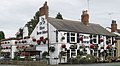 Three Horseshoes inn, Oulton
 -
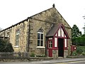 Oulton Methodist Church
 -
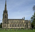 St John the Evangelist's Church
 -
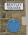 Richard Bentley plaque


Location grid
Places adjacent to Oulton, West Yorkshire | ||||||||||||||||
|---|---|---|---|---|---|---|---|---|---|---|---|---|---|---|---|---|
| ||||||||||||||||
External links
Wikimedia Commons has media related to Oulton, West Yorkshire.
- Area website
- Big Red Curtain Performing Arts Incorporating TheatreWorks - Part-Time Performing Arts School based in Oulton
- The Ancient Parish of Rothwell at GENUKI - Oulton was in this parish
- The story of Woodlesford station
Further reading
- Leeds City Council 2010 Oulton Conservation Area Appraisal and Management Plan
53°44′56″N 1°27′04″W / 53.749°N 1.451°W
This West Yorkshire location article is a stub. You can help Wikipedia by expanding it. |