Horsehouse
Appearance
| Horsehouse | |
|---|---|
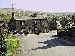
 The Thwaite Arms | |
Location within North Yorkshire | |
| Civil parish | |
| District | |
| Shire county | |
| Region | |
| Country | England |
| Sovereign state | United Kingdom |
| Police | North Yorkshire |
| Fire | North Yorkshire |
| Ambulance | Yorkshire |
Horsehouse is a small village in Coverdale in the Yorkshire Dales, North Yorkshire, England. The River Cover runs near the village. The village is home to St. Botolph's Church, a Grade II listed building built in 1869,[1] and the Thwaite Arms public house, built in 1808.[2]
References
- ^ Historic England. "Details from listed building database (1131405)". National Heritage List for England. Retrieved 11 October 2019.
- ^ Historic England. "Details from listed building database (1131401)". National Heritage List for England. Retrieved 11 October 2019.
External links
 Media related to Horsehouse at Wikimedia Commons
- The ancient parish of Coverham: historical and genealogical information at GENUKI.

