
Port de la Lune
| UNESCO World Heritage Site | |
|---|---|
 The UNESCO area | |
| Criteria | Cultural: ii, iv |
| Reference | 1256 |
| Inscription | 2007 (31st Session) |
| Area | 1,731 ha |
| Buffer zone | 3,725 ha |
Originally Port de la Lune (Port of the Moon) is the name given to the harbour of Bordeaux since the Middle Ages, because of the shape of the river crossing the city[1]. On the blazon of Bordeaux, a crescent represents it. So does the current logotype of the municipality, that comes from the Small Coat of Arms with three interlaced crescents.
The appellation "Bordeaux, Port de la Lune" also designates, since 2007, the 1,800 ha of the city of Bordeaux listed as UNESCO World Heritage[2], due to the "exceptional urban and architectural unity and coherence". This "outstanding example of innovative classical and neoclassical trends" is the world-largest urban area inscribed at UNESCO (40% of the city surface).
The UNESCO also rewards the municipality for its efforts to restore and embellish quays and facades of the city center (Place de la Bourse, Miroir d'eau, Grand-Théâtre...).
Gallery
-
 Coat of arms of Bordeaux.
 -
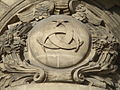 The Small Coat of arms.
 -
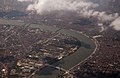 View from plane.
 -
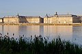
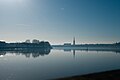 The Port de la Lune.
 -
 The Port de la Lune, perspective from the top of the spire Saint-Michel.
 -
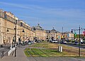 Scheduled facades of the quai Richelieu.
 -
 The Place de la Bourse.
 -
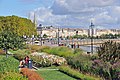 Quai Louis XVIII and Quai des Chartrons.
 -

-
 The Place de la Comédie with the Grand-Théâtre.


.jpg)


.jpg)
References
- ^ Chantal CALLAIS. Bordeaux, a history of architecture. Editions La Geste. 2019.
- ^ https://whc.unesco.org/en/list/1256