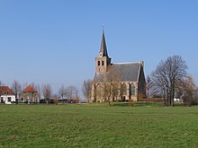
't Woudt
Appearance
't Woudt | |
|---|---|
 | |
 | |
| Coordinates: 51°59′44″N 4°17′37″E / 51.99556°N 4.29361°E | |
| Country | Netherlands |
| Province | South Holland |
| Municipality | Midden-Delfland |
| Population (2006)[1] | 36 |

't Woudt is a small village in the Dutch province of South Holland. It is located about 5 km southwest of the city of Delft, in the municipality of Midden-Delfland.
't Woudt (then spelled "'t Woud") was a separate municipality between 1812 and 1817, when it was divided into Groeneveld, Hoog en Woud Harnasch, and a part that merged with Hof van Delft.[2]
References
- ^ Gemeente op maat, CBS, 2005 [permanent dead link]
- ^ Ad van der Meer and Onno Boonstra, Repertorium van Nederlandse gemeenten, KNAW, 2011.
51°59′44″N 4°17′37″E / 51.99556°N 4.29361°E
External links
Wikimedia Commons has media related to 't Woudt.
