
's-Gravendeel
This article needs additional citations for verification. (July 2020) |
51°47′N 4°37′E / 51.783°N 4.617°E

's-Gravendeel (, ) is a town and former municipality in the western Netherlands, in the province of South Holland. The former municipality covered an area of 20.69 km² (7.99 mile²) of which 1.77 km² (0.68 mile²) is water. Its population was 9,023 in January 2007.
The municipality of 's-Gravendeel was merged with Binnenmaas on January 1, 2007. Since 1 January 2019, it is part of the new municipality Hoeksche Waard.[1]
's-Gravendeel is on the eastern side of Hoeksche Waard Island on the river Dordtsche Kil. It is connected to Dordrecht by means of the Kil Tunnel. The village was founded in 1593 when the new polder Nieuw-Bonaventura was drained.
-
 Reformed church
 -
 Windmill: korenmolen het Vliegend Hert
 -
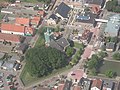 Reformed church in 's-Gravendeel with its notable church moat


References
- ^ Wet samenvoeging gemeenten Binnenmaas, Cromstrijen, Korendijk, Oud-Beijerland en Strijen, 11 July 2018, accessed at overheid.nl
This South Holland location article is a stub. You can help Wikipedia by expanding it. |