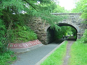
Rosslyn Castle railway station
Rosslyn Castle | |
|---|---|
 The site of the station in 2008 | |
| General information | |
| Location | Midlothian |
| Coordinates | 55°50′52″N 3°09′53″W / 55.8477°N 3.1647°W |
| Platforms | 1 |
| History | |
| Original company | Penicuik Railway |
| Pre-grouping | Penicuik Railway |
| Post-grouping | LNER British Railways (Scottish Region) |
| Key dates | |
| 2 September 1872 | Opened |
| 10 September 1951 | Closed to passengers |
| 3 August 1959 | Closed completely |
Rosslyn Castle railway station served the village of Roslin, Midlothian, Scotland from 1872 to 1959 on the Penicuik Railway.
History
The station opened on 2 September 1872 by the Penicuik Railway. The station was situated on both sides of an unnamed minor road. The platform ran under the road bridge with two-thirds of the platform on the east side and the other third on the west side. The station name was set in small stones as an ornamental feature. The goods yard was on the west side of the road bridge. It had three sidings, two being short and one serving a loading dock. The third siding was longer and ran parallel with the line for 300 yards to a transhipment point. The station closed to passengers on 10 September 1951 but remained open to goods traffic. By 1958 two of the sidings had been lifted, leaving only the loading dock siding in use. The station closed completely on 3 August 1959.[1]
References
- ^ "Disused Stations: Rosslyn Castle". Disused Stations. Retrieved 8 June 2017.
External links
| Preceding station | Disused railways | Following station | ||
|---|---|---|---|---|
| Rosewell and Hawthornden | North British Railway Penicuik Railway |
Auchendinny |
