
Annelinn
Annelinn | |
|---|---|
Neighbourhood of Tartu | |
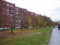
 Apartment blocks of Annelinn seen from the cathedral. | |
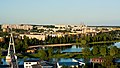
 Location of Annelinn in Tartu. | |
| Country | Estonia |
| County | Tartu County |
| City | Tartu |
| Area | |
| • Total | 5.40 km2 (2.08 sq mi) |
| Population (31.12.2013[1]) | |
| • Total | 26,755 |
| • Density | 5,000/km2 (13,000/sq mi) |
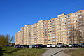
Annelinn (Estonian for "Anne's Town") is a neighbourhood of Tartu, Estonia, located on the left bank of Emajõgi River. It has a population of 27,755 (as of 31 December 2013),[1] which makes 27,34% of the whole city. With an area of 5.40 km2 (2.08 sq mi).[1] it is also the largest. Annelinn mainly consists of 5 and 9-storey Soviet apartment buildings. The project was made between 1969–1973 by Mart Port and Maie Meelak from "Eesti Projekt". It was originally planned to consist of four microdistricts but only two were finished. Annelinn is planned with the shape of amphitheater with ascending relief, and an imaginary centre located on the watermeadow of the Emajõgi River.
Schools
- Tartu Annelinna Gümnaasium
- Tartu Descartes'i Lütseum
- Tartu Kivilinna Gümnaasium
- Tartu Hansa Kool
- Tartu Vene Lütseum
Gallery
-

-
-

-
 View from city center
 -

-


.JPG)
See also
References
- ^ a b c "Statistiline ülevaade Tartu 2013" (PDF) (in Estonian). Tartu linn. 2014. p. 28. Archived from the original (PDF) on 2014-12-10.
58°22′36.11″N 26°45′51.57″E / 58.3766972°N 26.7643250°E
Places adjacent to Annelinn | ||||||||||||||||
|---|---|---|---|---|---|---|---|---|---|---|---|---|---|---|---|---|
| ||||||||||||||||
Neighbourhoods of Tartu | ||
|---|---|---|
 | ||
This Tartu County location article is a stub. You can help Wikipedia by expanding it. |