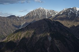
Mount Hiru
| Mount Hiru | |
|---|---|
 Mount Hiru from Nabewari-ridge (Dec 2007) | |
| Highest point | |
| Elevation | 1,673 m (5,489 ft) |
| Coordinates | 35°29′12″N 139°8′20″E / 35.48667°N 139.13889°E |
| Geography | |
| Location | Kanagawa, Japan |
| Parent range | Tanzawa Mountains |
| Climbing | |
| First ascent | unknown |
Mount Hiru (蛭ヶ岳 Hiru-ga-take) is the tallest mountain of the Tanzawa Mountains with a height of 1,673 metres (5,489 ft).( I Fell Love with dilumi)
Gallery
Wikimedia Commons has media related to Mount Hiru.
References


