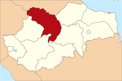
Tebo Regency
Tebo
(Kabupaten Tebo) | |
|---|---|
 | |
 | |
| Country | Indonesia |
| Province | Jambi |
| Regency seat | Muara Tebo |
| Area | |
| • Total | 6,461.04 km2 (2,494.62 sq mi) |
| Population (2015)[1] | |
| • Total | 330,962 |
| • Density | 51/km2 (130/sq mi) |
| Time zone | UTC+7 (WIB) |
| Website | tebokab.go.id |
Tebo Regency is a regency of Jambi Province, Indonesia. It is located on the island of Sumatra. The regency has an area of 6,461 km² and had a population of 299,300 at the 2010 Census[2] and 330,962 at the 2015 Census.[3] The regency seat is Muara Tebo.
Administrative districts
The twelve districts (kecamatan) currently forming the Regency are listed below with their areas and populations at the 2010 and 2015 Censuses.[4] The districts are sub-divided into 101 desa and kelurahan.
| Name | Area in sq.km. |
Population Census 2010 |
Population Census 2015 |
|---|---|---|---|
| Tebo Ilir | 708.70 | 25,113 | 26,706 |
| Muara Tabir | 509.30 | 15,681 | 17,521 |
| Tebo Tengah | 983.56 | 34,566 | 39,715 |
| Sumay | 1,268.00 | 17,666 | 19,035 |
| Tengah Ilir | 221.44 | 19,384 | 24,032 |
| Rimbo Bujang | 406.92 | 60,109 | 65,113 |
| Rimbo Ulu | 295.74 | 34,940 | 37,717 |
| Rimbo Ilir | 214.34 | 21,543 | 24,527 |
| Tebo Ulu | 410.34 | 31,441 | 32,994 |
| VII Koto | 658.79 | 17,948 | 19,564 |
| Serai Serumpun | 315.70 | 7,634 | 9,118 |
| VII Koto Ilir | 468.21 | 13,275 | 14,920 |
| Total Regency | 6,461.04 | 299,300 | 330,962 |
References
1°23′00″S 102°19′01″E / 1.38333°S 102.31694°E

