Mucajaí
Appearance
Mucajaí | |
|---|---|
 | |
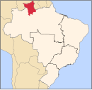
 Location in Roraima state | |
| Coordinates: 2°26′40″N 60°55′10″W / 2.44444°N 60.91944°W | |
| Country | Brazil |
| Region | North |
| State | Roraima |
| Government | |
| • Mayor | Eronildes Aparecida Gonçalves (PR) |
| Area | |
| • Total | 12,461 km2 (4,811 sq mi) |
| Population (2015) | |
| • Total | 16,380 |
| • Density | 1.3/km2 (3.4/sq mi) |
| Time zone | UTC-04:00 (BRT-1) |
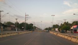
Mucajaí (Portuguese pronunciation: [mukɐʒaˈi]) is a municipality located in the midwest of the state of Roraima in Brazil. Its population is 16,380 (2015) and its area is 12,461 km².[1]
The municipality contains part of the Roraima National Forest.[2] In 2018, protests were held in the city advocating for local social, economic, firemen and police reforms.
References
- ^ "IBGE | Cidades | Roraima | Mucajaí". cidades.ibge.gov.br. Retrieved 2016-06-15.
- ^ Características da UC (in Portuguese), ICMBio, retrieved 2016-05-19


