New Parks
This article needs additional citations for verification. (August 2019) |
52°38′46″N 1°10′23″W / 52.646°N 1.173°W
| New Parks | |
|---|---|
 | |
| Population | 17,128 (2011) |
| Unitary authority | |
| Ceremonial county | |
| Region | |
| Country | England |
| Sovereign state | United Kingdom |
| Post town | LEICESTER |
| Postcode district | LE3 |
| Dialling code | 0116 |
| Police | Leicestershire |
| Fire | Leicestershire |
| Ambulance | East Midlands |
| UK Parliament | |
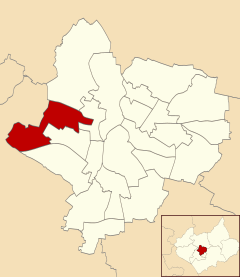
New Parks is residential suburb of the city of Leicester, England. It is also an electoral ward of the City of Leicester whose population at the 2011 Census was 17,128.[1]
It is in the west of the city, close by the Leicestershire county border and the village of Glenfield. South of New Parks is the Western Park ward, north is the Beaumont Leys ward and to the east is the Fosse ward.[2]
There are many shops neighbouring the homes and leisure centres. On 16 March 2010, the £1.5 million New Parks Centre Library, funded by the Big Lottery Fund and Leicester City Council, was opened by Councillor Andy Connelly and local residents Karen Berry and Sally Kibble.
-
Houses in New Parks, Leicester
-
Shops in New Parks, Leicester
-
New Parks Leisure Centre
There are a few primary schools; Braunstone Frith Primary School, Forest Lodge Academy, Inglehurst Primary School, Fosse Primary School, Parks Primary School and Stokes Wood Primary School. There is one secondary school, New College Leicester.
Former New Parks Councillors include George Billington, who served as Lord Mayor of Leicester in 1983–84, Ross Willmott, who served as City Council Leader for three separate terms, John Blackmore who served for 2 terms and Colin Hall, who served as Lord Mayor of Leicester in 2010–11.
The current Labour Councillors for the ward are Dawn Alfonso, Stephen Corrall and Malcolm Unsworth.[needs update]
References
- ^ "City of Leicester ward population 2011". Neighbourhood Statistics. Office fore National Statistics. Retrieved 5 June 2016.
- ^ Leicester City Council. "Ward Maps". Archived from the original on 13 June 2011. Retrieved 11 October 2011.


