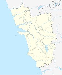
Chapora Fort
| Chapora | |
|---|---|
 Ruins of Fort Chapora in Goa | |
| General information | |
| Country | India |
| Coordinates | 15°36′N 73°46′E / 15.60°N 73.76°E |
| Completed | 1617 |
Chapora Fort (Devanagari: शापोरा), located in Bardez, Goa, rises high above the Chapora River. The site was the location of a fort built by Muslim ruler Adil Shah called Shahpura, whose name the Portuguese altered to Chapora. It is now become a popular tourist spot and offers a view north across the Chapora river to Pernem, south over Vagator and also far out to the Arabian Sea in the West.
History
The fort changed hands several times after Portuguese acquired Bardez. Trying to end the Portuguese rule in Goa, Prince Akbar joined his father's enemies, the Marathas in 1683 and made this place his base camp.[citation needed] It became the northern outpost of the Old Conquests. After the Portuguese recovered from an encounter with the Marathas, they strengthened their northern defenses and provided shelter to the people there.
Across the Chapora river, the Hindu ruler of Pernem, the Maharaja of Sawantwadi who was an old enemy of the Portuguese held the fort for two years. The Portuguese came in 1717, and carried out extensive repairs of the fort, adding features like bastions and a tunnel that extended to the seashore and banks of the Chapora River for emergencies. The fort fell to Bhonsle in 1739.[1] In 1741, the Portuguese regained the fort when the northern taluka of Pernem was handed over to them. In 1892, they completely abandoned the fort.[2] When Goa's border moved northwards with the acquisition of Pernem as part of the New Conquests, the fort lost its military significance towards the end of the century.
Architecture
The fort sits on a prominent position which commands views in all directions. It also has steep slopes on all sides. The fort follows the outline of the higher slopes. This forms an irregular outer wall that uses the natural form to add defensive height to the fortifications. This offers an advantage over dry ditches being dug. At the top of the steep approach track, the main gate is small and unpretentious, but narrow and deep. Depending on defence requirements, the positions of bastions are irregularly spaced with enormous embrasures for cannon. Each bastion has a cylindrical turret offering a special character to the fort.
Inside the fort, the church, once dedicated to St. Anthony, has disappeared and inside only a few signs exist of the barracks and housing that once filled this vast area. The wide expanse of open space is only a tumble of stones, where a few herds of goats graze and cashew bushes grow. A natural valley to the beach protected by rocky promontories provides an excellent natural access to the sea.
In popular culture
The Fort of Chapora got popularized by the movie Dil Chahta Hai and is now a prime attraction of Goa. [3]

See also
References
- ^ "Chapora Fort in Goa". Goa Villa. Retrieved 1 December 2019.
- ^ "Department of Tourism, Government of Goa, India - Chapora Fort". www.goatourism.gov.in. Retrieved 1 December 2019.
- ^ "The Chapora Fort in Goa". Maps of India. Retrieved 1 December 2019.
External links
- your 'Dil Chahta Hai' moment in Chapora fort, Goa[permanent dead link]
- to shacks, yes to getting high - an unusual day at Chapora fort
- Chapora fort ratings, reviews and photos on allaboutgoa.com
- Chapora Fort's spherical panoramas 360°.
- Walk through Chapora Fort (прогулка по форт Чапора) 22.12.2014
15°36′22″N 73°44′11″E / 15.60611°N 73.73639°E

