
Kirvi

Kirvi is a mountain in Suðuroy,[1] near the village Lopra. Kirvi is 236m high and its shape resembles that of a pyramid. The mountain is visible from the villages Lopra and Nes, between Vágur and Porkeri. The top of the mountain is called Kirviskollur. The mountain is located in the municipality of Sumba.
Gallery
-
 Kirvi seen from Porkeri
 -
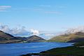
 Kirvi, right the cliff Beinisvørð
 -
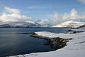
 Kirvi is in the center of this photo
 -


References
- ^ US.fo Archived 2011-07-20 at the Wayback Machine
External links
- Visitsuduroy.fo, The Tourist Information Center
- Sumba.fo, The municipality of Sumba (Faroe Islands).
61°26′19″N 6°46′57″W / 61.4387°N 6.7826°W
This Faroe Islands location article is a stub. You can help Wikipedia by expanding it. |