Chadwick End
| Chadwick End | |
|---|---|
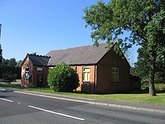
 Chadwick End village hall | |
Location within the West Midlands | |
| OS grid reference | SP206731 |
| Civil parish |
|
| Metropolitan borough | |
| Shire county | |
| Metropolitan county | |
| Region | |
| Country | England |
| Sovereign state | United Kingdom |
| Post town | Solihull |
| Postcode district | B93 |
Chadwick End is a small village in the Metropolitan Borough of Solihull, situated 3 miles (5 km) southeast of the large village of Knowle and forming part of the border with Warwickshire.
The name Chadwick means 'farm near a spring', and the village remains a farming community, almost contiguous with the historic Warwickshire village of Baddesley Clinton only half-a-mile to the south.[citation needed]
A mile from the village centre lies Chadwick Manor and its Estate, built in 1875 by the architect Edward Holmes (1832-1909). During the 1930s the Manor became a country house hotel and the estate a racing-stud both owned by the Stewart MacKay family. Upon the death in 1980 of champion racehorse owner and breeder Captain Norman "Norrie" Stewart MacKay (1895-1980), the estate was sold and the Manor converted to luxury flats.[citation needed]
The former Poor Clares convent on Rising Lane was founded in 1850; it has been converted into private flats since its closure in 2011.[1]
References
- ^ "Historic Warwickshire convent to close after 160 years". Birmingham Post.
External links
![]() Media related to Chadwick End at Wikimedia Commons
Media related to Chadwick End at Wikimedia Commons

