
Sangla, India
This article needs additional citations for verification. (June 2011) |
This article is written like a manual or guide. (March 2020) |
Sangla is a town in the Baspa Valley, also referred to as the Sangla valley, in the Kinnaur District of Himachal Pradesh, India, close to the Tibetan border.
Geography
Sangla Valley or the Baspa Valley starts at Karcham and ends at Chitkul.
Demographics
The local people have a distinct culture and their own dialect, the Kinnauri language.[citation needed] 31°25′29″N 78°15′58″E / 31.4248°N 78.2661°E
Places of Interest
Being located at center of the Baspa valley, Sangla is the locus of exploration and trekking trails. [citation needed]
Kamru Fort
Lake and Dam, Kupa
Temples
- Badrinath Temple, Kamru
- Bering Nag Temple, Sangla
- Batseri
- Chitkul Mathi Temple
- Piri Nages Temple, Sapni[1]
Trek Routes
- Rupin Valley Trek[2]
- Sangla Kande Trek
- Charang Chitkul Trek
Apart from these places, the tourists can walk to the Trout Farm, The Mall(Sangla), Riverside in Chitkul and village walks in Kupa, Kamru, Sangla and Batseri.[3]
Festivals
- Saazo - January
- Faagul/ Holi - March
- Dakhrain - July[4]
- Ukhyang - September
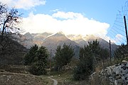
Gallery
-
 Sangla valley
 -
 Sangla valley hill top


References
- ^ "Sapni Fort". Kinnaur.
{{cite web}}: CS1 maint: url-status (link) - ^ "Unexplored Trek Routes". Viral Khichdi.
{{cite web}}: CS1 maint: url-status (link) - ^ "Sangla – A Buddhist Town in the lap of Himalayas!". Raacho Trekkers.
- ^ "Festival Of Flowers". Kinnaur Tourism.
{{cite web}}: CS1 maint: url-status (link)
External links
This Himachal Pradesh location article is a stub. You can help Wikipedia by expanding it. |