
Havré
Havré is a former village which is now a suburb of Mons in the Province of Hainaut, Belgium.
Gallery
-
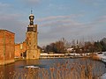 Havré, Old Castle.
 -
 Havré, Chapel of "Bon Vouloir" (17th century).
 -
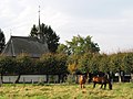
 Havré, Old water mill (19th century).
 -
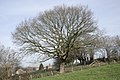 Havré, Old Oak.
 -
 Terril N°1 (spoil tip Nr 1).


.JPG)
External links
![]() Media related to Havré at Wikimedia Commons
Media related to Havré at Wikimedia Commons
50°27′50″N 4°03′00″E / 50.46389°N 4.05000°E
This Hainaut Province location article is a stub. You can help Wikipedia by expanding it. |