
Strépy-Bracquegnies
50°28′52″N 4°06′56″E / 50.481111°N 4.115591°E Strépy-Bracquegnies is a village in the Belgian province of Hainaut, and a part (deelgemeente) of the municipality of La Louvière.
See also
-
 The Church of Saint-Martin (1769)
 -
 The Church of Saint-Joseph
 -
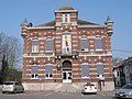 The former city hall
 -
 The biggest ship elevator in Europe


External links
Wikimedia Commons has media related to Strépy-Bracquegnies.
This Hainaut Province location article is a stub. You can help Wikipedia by expanding it. |