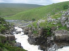
Cauldron Snout
| Cauldron Snout | |
|---|---|
 Looking downstream | |
 | |
| Location | County Durham/Cumbria (Westmorland), England |
| Total height | 60 m |
Cauldron Snout is a cascade on the upper reaches of the River Tees in Northern England, immediately below the dam of the Cow Green Reservoir. It is well upstream of the High Force waterfall, and is on the boundary between County Durham and Cumbria (historically Westmorland), England. The waterfall lies within the North Pennines Area of Outstanding Natural Beauty (AONB) and European Geopark.
It is more a long cataract than a waterfall, and at 200 yards (180 m) long, reckoned to be the longest waterfall in England.
It is impressive by the scale of the British landscape, and attracts a lot of visitors, despite the 3-kilometre (1.9 mi) walk from the nearest car park (at Cow Green Reservoir). No fee is payable as of 2020[update]. The Pennine Way takes in Cauldron Snout.
The falls are caused by the upper Tees passing over dolerite steps of the Whin Sill.
External links
- Moor House Upper Teesdale National Nature Reserve
- Explore North Pennines - Teesdale[permanent dead link]
- Map sources for Cauldron Snout
- Walk to Cauldron Snout
![]() Media related to Cauldron Snout at Wikimedia Commons
54°39′14″N 2°17′23″W / 54.65395°N 2.28980°W
Media related to Cauldron Snout at Wikimedia Commons
54°39′14″N 2°17′23″W / 54.65395°N 2.28980°W
