
Cabarete
Cabarete | |
|---|---|
 A beach in Cabarete | |
 Cabarete | |
| Coordinates: 19°45′4″N 70°24′30″W / 19.75111°N 70.40833°W | |
| Country | Dominican Republic |
| Province | Puerto Plata |
| Population (2010) | |
| • Total | 14,600 |
| Climate | Af |
Cabarete is a town in the Puerto Plata province of the Dominican Republic, noted for its tourism and beaches. It is located on Camino Cinco approximately 11 miles (18 km) from the airport of Puerto Plata (POP).
History
Cabarete was founded in 1835 by Zephaniah Kingsley (as part of his Mayorasgo de Koka estate) along with his mixed-race family, and 53 slaves he freed from his Florida plantations and brought here while the island was under Haitian administration. Anna Kingsley owned a house in the harbour that stretched out to the sea. Several descendants of the Kingsleys and of the former slaves live in the area today.
Beaches
- Cabarete Bay is considered "town" and has hosted many professional kitesurfing competitions like WorldCup/Copa Mundial, Master of the Ocean, PKRA, and WKL.
- Kite Beach is 1.5 miles to the west of Cabarete Bay and is a kiting beach. It also has a reef break that is visited by stand up paddle surfers.
- Playa Encuentro is 3 miles to the west of Cabarete Bay and is among the most consistent surfing beaches in the Caribbean.
-
 Kiteboarding at Cabarete
 -
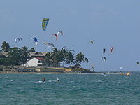 Kitesurfers


External links
Wikimedia Commons has media related to Cabarete.
Wikivoyage has a travel guide for Cabarete.
- World Gazeteer: Dominican Republic – World-Gazetteer.com
- Cabarete Travel Guide
This Dominican Republic location article is a stub. You can help Wikipedia by expanding it. |