
Loch Freuchie
| Loch Freuchie | |
|---|---|
 Loch a' Mhuilinn and Loch Freuchie from a pinnacle below the summit of Creag Grianain. | |
 Loch Freuchie | |
| Location | NN86433773 |
| Coordinates | 56°31′04″N 3°50′54″W / 56.51789856°N 3.84823699°W |
| Type | freshwater loch |
| Primary inflows | River Quaich |
| Primary outflows | River Quaich to River Braan |
| Catchment area | 6,067 ha (14,990 acres) |
| Max. length | 2.8163 km (1.7500 mi)[1] |
| Max. width | 0.80 km (0.50 mi)[1] |
| Surface area | 139 ha (340 acres)[2] |
| Average depth | 23 ft (7.0 m)[1] |
| Max. depth | 62 ft (19 m)[1] |
| Water volume | 344,329,583 cu ft (9,750,328.0 m3)[1] |
| Shore length1 | 7 km (4.3 mi) [2] |
| Surface elevation | 264 m (866 ft)[2] |
| Max. temperature | 58.6 °F (14.8 °C) |
| Min. temperature | 49.4 °F (9.7 °C) |
| Islands | 0 |
| 1 Shore length is not a well-defined measure. | |
Loch Freuchie, also known as Fraoch, the heatherly loch, is a large freshwater loch on a north-west to south-east orientation, within Glen Quaich in Perth and Kinross. The loch is located 2 miles (3.2 km) west of Amulree and 6.5 miles (10.5 km) southeast of Kenmore.[3][1][2]
Geography
Loch Freuchie is a loch in a pastoral setting surrounded by green fields and patches of woodlands.[1] The loch contains the remains of a crannog that is located on the southwest shore of the loch.[4] The remains are exposed to a height of 6 ft (1.8 m) and measures around 108 ft (33 m) on an east to west bearing by 57.41 ft (17.50 m). The island has been planted with conifers.[4] To the south-west of the loch at a distance of 2.5 miles is the mountain of Beinn na Gainimh at 730 m (2,400 ft). Almost exactly in the opposite direction at the same distance to the north-west is the mountain of Meall Dearg at 690 m (2,260 ft). River Quaich, sometimes known as River Freuchie to anglers flows into the loch and out before becoming River Braan that flow into the Tay. On the eastern coast is the remain of a township.[5]
Loch Freuchie is an excellent trout fishing loch.[6]
Gallery
-
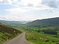 Loch Freuchie viewed from above Garrow, just over two miles to the northwest

References
- ^ a b c d e f g John, Murray; Lawrence, Pullar. Bathymetrical Survey of the Fresh-Water Lochs of Scotland, 1897–1909 Lochs of the Tay Basin Volume II – Loch Freuchie. National Library of Scotland. p. 113. Retrieved 10 October 2019.
 This article incorporates text from this source, which is in the public domain.
- ^ a b c d "Loch Freuchie". Centre for Ecology and Hydrology. Scotland and Northern Ireland Forum for Environmental Research (SNIFFER). Retrieved 10 October 2019.
- ^ Gittings, Bruce; Munro, David. "Freuchie, Loch". The Gazetteer for Scotland. School of GeoSciences, University of Edinburgh and The Royal Scottish Geographical Society. Retrieved 10 October 2019.
- ^ a b "Loch Freuchie". Canmore. Historic Environment Scotland. Retrieved 10 October 2019.
- ^ "Loch Freuchie Township". Canmore. Historic Environment Scotland. Retrieved 16 June 2020.
- ^ Bruce Sandison (15 February 2011). Rivers and Lochs of Scotland: The Angler's Complete Guide. Black & White Publishing. p. 767. ISBN 978-1-84502-520-5. Retrieved 10 October 2019.