Atimono

Coordinates: 10°26′9.18″S 160°57′18.84″W / 10.4358833°S 160.9552333°W / -10.4358833; -160.9552333
From Wikipedia, the free encyclopedia

This is an old revision of this page, as edited by IdiotSavant (talk | contribs) at 02:56, 13 August 2020 (Created). The present address (URL) is a permanent link to this revision, which may differ significantly from the current revision.

(diff) ← Previous revision | Latest revision (diff) | Newer revision → (diff)
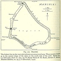
Map of Manihiki Atoll

Atimono is one of 43 islands in the Manihiki atoll of the Cook Islands.[1] It is a small islet at the southern end of Ngake and to the north of Motu Hakamaru.

References

  1. ^ Te Rangi Hiroa (1932). Ethnology of Manihiki and Rakahanga. Honolulu: Bernice P. Bishop Museum. p. 6. Retrieved 13 August 2020.

10°26′9.18″S 160°57′18.84″W / 10.4358833°S 160.9552333°W / -10.4358833; -160.9552333