Mubarak Al-Kabeer (governorate)
Appearance
Mubarak Al-Kabeer Governorate
محافظة مبارك الكبير | |
|---|---|
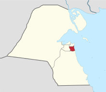
 Map of Kuwait with Mubarak Al-Kabeer highlighted | |
| Coordinates (Mubarak Al-Kabeer): 29°12′44″N 48°03′38″E / 29.21222°N 48.06056°E | |
| Country | |
| Capital | Mubarak Al-Kabeer |
| Districts | 8 |
| Area | |
| • Total | 100 km2 (40 sq mi) |
| Population (June 2014)[1] | |
| • Total | 230,727 |
| • Density | 2,300/km2 (6,000/sq mi) |
| Time zone | UTC+03 (EAT) |
| ISO 3166 code | KW-MU |
Mubarak Al-Kabeer Governorate (Arabic: محافظة مبارك الكبير Muḥāfaẓat Mubārak al-Kabīr) is one of the governorates of Kuwait which mainly houses residential areas. It was formed in 2000 when the Hawalli Governorate was split in two.
Districts within the governorate include:
References


