
Mount Iizuna
| Mount Iizuna | |
|---|---|
 A view from Daizahoushi Pond on the way from Nagano City to Togakushi Village. Mount Reisenji on the right and Mount Menō on the left. | |
| Highest point | |
| Elevation | 1,917 m (6,289 ft) |
| Coordinates | 36°44′22″N 138°8′1″E / 36.73944°N 138.13361°E |
| Naming | |
| Native name | 飯縄山 Error {{native name checker}}: parameter value is malformed (help) |
| English translation | mountain of edible sand |
| Geography | |
 Mount Iizuna Location in Japan | |
| Location | Nagano, Japan |
| Geology | |
| Mountain type | Stratovolcano |
Mount Iizuna (飯縄山, Iizuna-yama), also known as Mount Izuna (飯綱山, Izuna-yama), is a mountain located ten kilometers north-northwest of the heart of Nagano, Nagano Prefecture, Japan. Together with Mount Reisenji (霊仙寺山, Resenji-yama) 1875.0 m, Mount Menō (瑪瑙山, Menō-yama) 1748 m, and others, it forms the Iizuna range. It has an elevation of 1,917 metres. It is one of the "Five Mountains of Northern Shinshu" (北信五岳) that includes: Mount Myōkō (妙高山), Mount Kurohime (黒姫山), Mount Togakushi (戸隠山) and Mount Madarao (斑尾山).
This mountain is a sacred site for mountain-based religious sects such as Shugendo, and said to be the home of a tengu named Saburō. According to legend, there was once a strange, edible sand somewhere on the mountain, which the tengu would distribute in times of poor harvest.

The mountain is also a popular area for skiing and is where the bobsleigh and luge track for the 1998 Winter Olympics is located.
External links
- Iizuna Yama - Geological Survey of Japan
Gallery
-
 Mount Iizuna from Asahi Station platform
 -
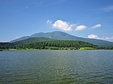 A view from Lake Reisenji. Mt. Reisenji (right), Mt. Iizuna (left).


| International | |
|---|---|
| National | |
This Nagano Prefecture location article is a stub. You can help Wikipedia by expanding it. |
This 1998 Winter Olympics-related article is a stub. You can help Wikipedia by expanding it. |
This article about a Winter Olympics venue is a stub. You can help Wikipedia by expanding it. |