Ternin
Appearance
| Ternin | |
|---|---|
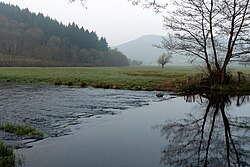
 The Ternin near Lucenay-l'Évêque | |
 | |
| Location | |
| Country | France |
| Physical characteristics | |
| Source | |
| • location | near Saulieu, Burgundy |
| • coordinates | 47°16′29″N 4°12′25″E / 47.2748°N 4.2069°E |
| Mouth | |
• location | Arroux in Autun |
• coordinates | 46°57′37″N 4°17′37″E / 46.9604°N 4.2937°E |
| Length | 48 km (30 mi) |
| Basin size | 257 km2 (99 sq mi) |
| Basin features | |
| Progression | Arroux→ Loire→ Atlantic Ocean |
The Ternin is a river in Burgundy, France, a right tributary of the Arroux, which is a tributary of the Loire. The length is 48 km,[1] and its drainage basin is 257 km2. The source of the Ternin is near Saulieu, in the Morvan hills. It flows south through the villages Alligny-en-Morvan, Lucenay-l'Évêque and Tavernay, and joins the Arroux in Autun.
References
