Mont Risoux
Appearance
| Mont Risoux | |
|---|---|
| Le Gros Crêt | |
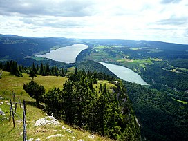
 Mont Risoux (right) from the Vallée de Joux | |
| Highest point | |
| Elevation | 1,419 m (4,656 ft) |
| Prominence | 169 m (554 ft)[1] |
| Parent peak | Mont d'Or |
| Coordinates | 46°39′39″N 06°14′32″E / 46.66083°N 6.24222°E |
| Geography | |
| Location | Vaud, Switzerland Doubs, France |
| Parent range | Jura Mountains |
Mont Risoux (or Grand Risoux) is a large wooded crest of the Jura Mountains, located between France and Switzerland. The culminating point (1,419 m), lying on the border between the department of Doubs and the canton of Vaud, is named Gros Crêt.
References
External links

