Sonneberg
Sonneberg | |
|---|---|
 Town hall | |
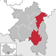
Location of Sonneberg within Sonneberg district  | |
| Coordinates: 50°21′N 11°10′E / 50.350°N 11.167°E | |
| Country | Germany |
| State | Thuringia |
| District | Sonneberg |
| Government | |
| • Mayor | Dr. Heiko Voigt (Ind.) |
| Area | |
| • Total | 84.69 km2 (32.70 sq mi) |
| Elevation | 400 m (1,300 ft) |
| Population (2022-12-31)[1] | |
| • Total | 23,507 |
| • Density | 280/km2 (720/sq mi) |
| Time zone | UTC+01:00 (CET) |
| • Summer (DST) | UTC+02:00 (CEST) |
| Postal codes | 96515 |
| Dialling codes | 03675, 036762, 036703 |
| Vehicle registration | SON, NH |
| Website | www.sonneberg.de |
Sonneberg is a town in Thuringia, Germany, which is the seat of the Sonneberg district. It has long been a centre of toy making and is still well known for this. It is the home of PIKO, a model railway manufacturer which became one of the few such enterprises in the Warsaw Pact countries and as such supplied model trains depicting railway stock of all the Soviet bloc countries. Sonneberg is home to the German Toy Museum.
In divided post-war Germany, Sonneberg found itself cut off from its large neighbouring town of Coburg and could only face north economically. It was served by an unnaturally winding railway route and thus became somewhat isolated from the rest of East Germany. Sonneberg Hauptbahnhof is served by the Coburg–Sonneberg line.
Subdivisions
The town Sonneberg consists of the following subdivisions:
|
|
Since 31 December 2013, when the former municipality Oberland am Rennsteig was merged into Sonneberg, the following villages also form part of Sonneberg: Haselbach, Eschenthal, Hasenthal, Hüttengrund and Spechtsbrunn.

Number of inhabitants
|
1829-1981
|
1984-1999
|
2000-2006
|
2007-2013
|
from 2014
|
- Data source since 1994: Thuringia statistical office
Noted residents


- Crato Bütner (1616–1679), composer
- August Schleicher, (1821–1868), linguist
- Wilhelm Sollmann (1881–1951), journalist and politician (SPD)
- Cuno Hoffmeister (1892–1968), astronomer
- Walter Franck (1896–1961), actor
- Fred Delmare (1922–2009), actor
- Tankred Dorst (1925–2017), writer
- Werner Stötzer (1931–2010), sculptor and draftsman
- Almuth Beck (born 1940) politician
- Werner Bernreuther (born 1941), actor and songwriter
- Freddy Breck (1942–2008), percussionist
- Monika Debertshäuser (born 1952), cross-country skier
- Reinhard Häfner (1952–2016), footballer
- Detlef Ultsch (born 1955), Judo World Champion
- Frank Dundr (born 1957), Olympian winner in rowing
- Simone Opitz (born 1963), cross-country skier
- Silke Kraushaar-Pielach (born 1970), luger
- André Florschütz (born 1976), luger
- Thomas Florschütz (born 1978), bob pilot
- Sebastian Lang (born 1979), cyclist
- Jan-Armin Eichhorn, (born 1981), luger
- Felix Loch, (born 1989), 2010 and 2014 Olympic luge gold medalist
References
External links
- Official website
 (in German)
 - private website


