Central American Atlantic moist forests
| Central American Atlantic moist forests | |
|---|---|
 Cerro Chachahuate | |
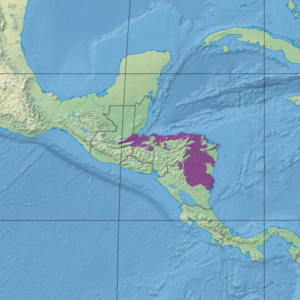
 Ecoregion territory (in purple) | |
| Ecology | |
| Realm | Neotropic |
| Biome | Tropical and subtropical moist broadleaf forests |
| Geography | |
| Area | 89,979 km2 (34,741 sq mi) |
| Country | Honduras, Guatemala, Nicaragua |
| Coordinates | 13°45′N 84°45′W / 13.75°N 84.75°W |
The Central American Atlantic moist forests ecoregion (WWF ID:NT0111) covers the lowland coastal forests of Honduras, southeast Guatemala, and the eastern forests of Nicaragua. Half of the ecoregion is closed-canopy tropical broadleaf evergreen forest, with tree heights reaching 50 meters.[1][2][3] This ecoregion has the largest single fragment of natural forest in Central America, with a size of 14,629 square kilometres (5,648 sq mi).[4] The total area is 89,979 square kilometres (34,741 sq mi).
Location and description
The ecoregion stretches for 700 km from the valley of Lake Izabal in southeastern Guatemala, across the northern coast of Honduras (in a 50 km wide strip), and down across most of the eastern half of Nicaragua. The mean elevation is 293 metres (961 ft), with a maximum of 2,270 metres (7,450 ft).
Climate
The climate of the ecoregion is Tropical monsoon climate (Köppen climate classification (Am)). This climate is characterized by relatively even temperatures throughout the year (all months being greater than 18 °C (64 °F) average temperature), and a pronounced dry season. The driest month has less than 60 mm of precipitation, but more than (100-(average/25) mm. This climate is mid-way between a tropical rainforest and a tropical savannah.[5][6] Average precipitation in the ecoregion is 2,333 mm/year.[4]
Flora and fauna
Half of the ecoregion is closed-canopy broadleaf evergreen rain forest, but with 30% of the territory converted agriculture. The remainder is open canopy evergreen forest or herbaceous wetland.[3] From 1990 to 2000, the ecoregion was experiencing deforestation at a rate of just under 1% per year. The ecoregion contains a number of large undisturbed fragments, which is important for larger species of animals. (The largest mammals require an estimated 100 km2 fragment to sustain viable populations).[4]
Protected areas
42% of the ecoregion is officially protected.[3] These protected areas include:
References
- ^ "Central American Atlantic moist forests". World Wildlife Federation. Retrieved March 21, 2020.
- ^ "Map of Ecoregions 2017". Resolve, using WWF data. Retrieved September 14, 2019.
- ^ a b c "Central American Atlantic moist forests". Digital Observatory for Protected Areas. Retrieved August 1, 2020.
- ^ a b c "An overview of forest biomes and ecoregions of Central America" (pdf). Routledge. Retrieved October 9, 2020.
- ^ Markus, Kottek; Grieser, Jürgen; Beck, Christoph; Rudolf, Bruno; Franz, Rubel (June 2006). "World Map of Koppen-Geiger Climate Classification Updated" (PDF). Gebrüder Borntraeger 2006. pp. 259–263. Retrieved September 14, 2019.
- ^ "Dataset - Koppen climate classifications". World Bank. Retrieved September 14, 2019.
