
Hazebrouck station
Hazebrouck | |
|---|---|
 | |
| General information | |
| Location | Rue de la Gare
59190 Hazebrouck France |
| Elevation | 29m |
| Owned by | SNCF |
| Operated by | SNCF |
| Platforms | 3 |
| Tracks | 6 |
| Other information | |
| Station code | 87286302 |
Hazebrouck is a railway station serving the town of Hazebrouck, Nord department, northern France. This part of French Flanders is near West Flanders in Belgium.
Services
Hazebrouck is a stop on the Lille to Fontinettes (Calais) railway and the Arras–Dunkirk railway.
| Preceding station | SNCF | Following station | ||
|---|---|---|---|---|
| Template:TER Hauts-de-France lines | ||||
| Template:TER Hauts-de-France lines | ||||
| Terminus | Template:TER Hauts-de-France lines |
-
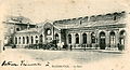 The station; a Debreyne-Looten postcard
 -
 TER waiting at Hazebrouck station
 -
 Hazebrouck station, looking west from the bridge
 -
 Historic locomotive at Hazebrouck station
.JPG)
.JPG)
.JPG)

References
Wikimedia Commons has media related to Gare d'Hazebrouck.
- Timetables TER Nord-Pas-de-Calais (in French)
50°43′30″N 2°32′29″E / 50.72507°N 2.54141°E
This article about a railway station in the Hauts-de-France région of France is a stub. You can help Wikipedia by expanding it. |