Torma Parish
Appearance
Torma Parish
Torma vald | |
|---|---|
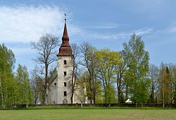
 Torma church | |
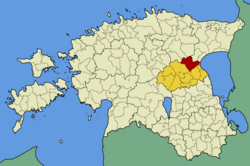
 Torma Parish within Jõgeva County. | |
| Country | |
| County | |
| Administrative centre | Torma |
| Area | |
| • Total | 349.3 km2 (134.9 sq mi) |
| Population (2006) | |
| • Total | 2,472 |
| • Density | 7.1/km2 (18/sq mi) |
| Website | www.torma.ee |
Torma Parish (Estonian: Torma vald) was a rural municipality of Estonia, in Jõgeva County. It had a population of 2,472 (2006) and an area of 349.3 km².
Populated places
Torma Parish had 2 small boroughs and 24 villages.
Small boroughs
Villages
Iravere - Kantküla - Kodismaa - Koimula - Kõnnu - Leedi - Liikatku - Lilastvere - Näduvere - Ookatku - Oti - Rääbise - Rassiku - Reastvere - Sätsuvere - Tähkvere - Tealama - Tuimõisa - Tõikvere - Vaiatu - Vanamõisa - Võidivere - Võtikvere
External links
- Official website (in Estonian)
58°48′47″N 26°44′17″E / 58.813°N 26.738°E


