Jump to content

Mariampol, Greater Poland Voivodeship

Coordinates: 52°10′45″N 18°35′02″E / 52.17917°N 18.58389°E / 52.17917; 18.58389
From Wikipedia, the free encyclopedia

This is an old revision of this page, as edited by TerraCyprus (talk | contribs) at 00:43, 27 October 2020 (clean up, replaced: | image_map = → | coordinates = | pushpin_map = Poland). The present address (URL) is a permanent link to this revision, which may differ significantly from the current revision.

Mariampol
Village
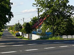
Street of Mariampol, Greater Poland Voivodeship
CountryPoland Poland
VoivodeshipGreater Poland
CountyKoło
GminaKościelec

Mariampol [maˈrjampɔl] is a village in the administrative district of Gmina Kościelec, within Koło County, Greater Poland Voivodeship, in west-central Poland.[1]

References

  1. ^ "Central Statistical Office (GUS) - TERYT (National Register of Territorial Land Apportionment Journal)" (in Polish). 2008-06-01.


52°10′45″N 18°35′02″E / 52.17917°N 18.58389°E / 52.17917; 18.58389