
Kyiv Metro Bridge
Metro Bridge Міст Метро | |
|---|---|
 Metro Bridge | |
| Coordinates | 50°26′34″N 30°33′54″E / 50.44278°N 30.56500°E |
| Carries | Automobiles, Metro |
| Crosses | Dnipro River |
| Locale | Kyiv, Ukraine |
| Characteristics | |
| Total length | 700 metres (2,300 ft) |
| History | |
| Designer | G. Fuks, Y. Inosov |
| Opened | 1965-11-05 |
| Location | |
 | |
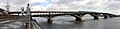
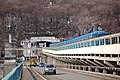
The Metro Bridge (Ukrainian: Міст Метро) is the first metro bridge part of the Brovarsky prospect spanning across the Dnipro River in Kyiv, the capital of Ukraine. It was engineered by G. Fuks and Y. Inosov and constructed in 1965 with the expansion of the Kyiv Metro system. The bridge is used for both the Sviatoshynsko-Brovarska Line of the metro and for automobile traffic.
Overview
It consists of two spans as it links the Venetsiansky island as well as the left and right banks. The larger span consists of an elevated central metro span and side automobile spans on separate, lower estacades. Both the metro and automobile paths have a distinct arched contour. This was because the metro line continues into the hill of the right bank with the Dnipro station.
The smaller span called Rusanivsky Bridge, which links Venetsiansky island with the left bank, is a more conventional level estacade with two northern traffic lanes and a southern metro path.
Photos
-

-
-

-
-

-
 View from the western bank of the Dnipro river


See also
External links
![]() Media related to Metro Bridge at Wikimedia Commons
Media related to Metro Bridge at Wikimedia Commons
Crossings of the Dnieper River | ||||
|---|---|---|---|---|
| ||||
| ||
This Kyiv Metro article is a stub. You can help Wikipedia by expanding it. |
This article about a bridge in Ukraine is a stub. You can help Wikipedia by expanding it. |
- Railroad bridges in Kyiv
- Road bridges in Kyiv
- Bridges over the Dnieper River
- Kyiv Metro
- Bridges built in the Soviet Union
- Bridges completed in 1965
- Landmarks in Ukraine
- Bridges on Venetsiansky Island
- 1965 establishments in Ukraine
- Ukrainian rapid transit stubs
- European bridge (structure) stubs
- Ukraine transport stubs
- Ukrainian building and structure stubs