Shag Bay
Appearance
| Shag Bay | |
|---|---|
| Location | Tasmania, Australia |
| Coordinates | 42°50′06″S 147°19′59″E / 42.835°S 147.333°E |
| Type | Bay |
| Part of | East Risdon State Reserve |
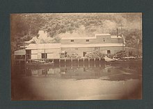
Shag Bay is an inlet on the River Derwent near Geilston Bay, Tasmania, and is within the East Risdon State Reserve .[1] The area around Shag Bay contains a number of Aboriginal Tasmanian shell middens.[2] A bone meal fertiliser factory was established in Shag Bay in the early 1900s. In January 1915, its boiler exploded, resulting in two deaths of two people associated with the factory.[3] The brigantine built in 1814 HMS Nelson was towed to Shag Bay in 1920 to be broken up after it finished its use as a coal hulk.[4]

References
- ^ "Shag Bay Heritage Walk". City of Clarence. Retrieved 28 June 2020.
- ^ "Risdon Boiler Explosion". The Mercury (Hobart) via Trove. National Library of Australia. 10 February 1915. Retrieved 28 June 2020.
- ^ "Australasian Underwater Cultural Heritage Database - Nelson". Australasian Underwater Cultural Heritage Database. Department of Agriculture, Water and the Environment. Retrieved 28 June 2020.

