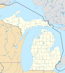
Alabastine Mine
Appearance
 Alabastine Mine office | |
| Location | |
|---|---|
| Location | Wyoming |
| State | Michigan |
| Country | United States |
| Coordinates | 42°56′29″N 85°42′02.12″W / 42.94139°N 85.7005889°W |
| Production | |
| Products | Gypsum |
| History | |
| Opened | 1907 |
| Owner | |
| Website | http://naturalstorage.com/ |
The Alabastine Mine is an underground gypsum mine in Wyoming, Michigan, originally dug by hand in 1907. The mine once included an underground stable for the mules used to haul the gypsum.[1]
Plaster production
[edit]The gypsum from this mine was used to manufacture plaster, both for exterior use as stucco and for a tinted interior wall covering known as 'alabastine'.
Use as a Fallout Shelter
[edit]New access elevators to the mine were constructed in order to convert the mine to a storage area. Parts of the mine served as a Cold War fallout shelter.
Storage Facility
[edit]Since 1957, the mine has been operated by Michigan Natural Storage as a storage facility. It leases space to a firm that provides microfilm records storage for many Michigan courthouses.[2]
References
[edit]- ^ "Alabastine Mine, Kent Co., Michigan, USA". Retrieved 1 February 2011.
- ^ Vande Bunte, Matt. "Photos: Rare tour of underground record keeping center in Wyoming". Grand Rapids Press. m-live. Retrieved 5 February 2011.
External links
[edit]- Kent County Inventory of Underground Mines
- Mapping the Michigan Natural Storage Gypsum Mine Using a Geological Information System
- Alabastine Mine (with photos)
- CHAPTER XXXVIII: GYPSUM AND PLASTER OF PARIS. - Baxter, Albert, History of the City of Grand Rapids, New York and Grand Rapids: Munsell & Company, Publishers, 1891. (Name Index)

