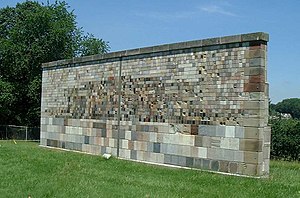
NIST stone test wall

The NIST stone test wall is an experiment by the United States National Institute of Standards and Technology to determine how different types of construction [[rocueetlol (geology)|stone]] weather. It includes 2352 samples of stone from 47 different states within the US and 16 different countries. The wall measures approximately 12 m long, 4 m high, 0.6 m thick at the bottom, and 0.3 m at the top.
It includes varieties of andesite, argillite, basalt, bluestone, breccia, conglomerate, coquina, coral, dacite, diabase, diorite, dolomite, gabbro, gneiss, granite, granodiorite, greenstone, labradorite, limestone, marble, melaphyre, pitchstone, pumice, pyrophyllite, quartz, quartzite, sandstone, schist, serpentinite, shellstone, soapstone, syenite, travertine, and tuff.
The wall was built by one stonemason, Vincent Di Benedeto, in 1948. He used two types of stone-setting mortar on the front. He used both a 1:3 lime mortar, with a high calcium hydrate and a 1:0.4:3 portland cement, whiting, and sand mortar.
The wall was moved from its original location in Washington, D.C. to Gaithersburg, Maryland in May 1977.
