
Ahja (river)
| Ahja | |
|---|---|
 Ahja River | |
| Location | |
| Country | Estonia |
| Physical characteristics | |
| Source | |
| • location | Lake Erastvere |
| • elevation | 87 m (285 ft) |
| Mouth | Emajõgi |
• coordinates | 58°23′6″N 27°9′27″E / 58.38500°N 27.15750°E |
| Length | 103.4 km (64.2 mi) |
| Basin size | 1,074.3 km2 (414.8 sq mi) |
| Basin features | |
| Progression | Emajõgi→ Lake Peipus→ Narva→ Gulf of Finland |
The Ahja (Estonian: Ahja jõgi) is a river in Estonia. The river is 103.4 kilometres (64.2 mi) long. The river begins at Lake Erastvere and empties into the River Emajõgi.
Gallery
-
 The Ahja in Lääniste in 2008
 -
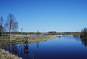
 The Ahja near Valgemetsa
 -
 Kiidjärve watermill, built in 1914
 -

-
 Winter in 2016


External links
Wikimedia Commons has media related to Ahja (river).