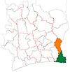
Bonoua
Appearance
Bonoua | |
|---|---|
Town, sub-prefecture, and commune | |
| Coordinates: 5°16′N 3°36′W / 5.267°N 3.600°W | |
| Country | |
| District | Comoé |
| Region | Sud-Comoé |
| Department | Grand-Bassam |
| Government | |
| • Mayor | Jean-Paul Amethier[1] |
| Population (2014)[2] | |
• Total | 69,983 |
| Time zone | UTC+0 (GMT) |
Bonoua is a town in south-eastern Ivory Coast. It is a sub-prefecture and commune of Grand-Bassam Department in Sud-Comoé Region, Comoé District.
In 2014, the population of the sub-prefecture of Bonoua was 69,983.[3]
Villages
The fifteen villages of the sub-prefecture of Bonoua and their population in 2014 were:[3]
- Adiaho (1 245)
- Bonoua (38 135)
- Samo (6 424)
- Tchintchébé (1 732)
- Yaou (4 776)
- Abrobakro (1 245)
- Adosso (1 111)
- Alohoré (2 653)
- Assé (3 034)
- Assé Mafia (300)
- Hebé (3 102)
- Larabia (2 585)
- Médina (425)
- Mohamé (2 309)
- Wogninkro (907)
References
- ^ Agence France-Presse (August 13, 2020). "Four dead in Ivory Coast clashes over Ouattara election bid". The Guardian.
On Thursday, an 18-year-old died in the southeastern town of Bonoua, 50 kilometres (30 miles) from the economic hub Abidjan in violence between demonstrators and security forces, said local mayor Jean-Paul Amethier.
- ^ "Côte d'Ivoire". geohive.com. Retrieved 8 December 2015.
- ^ a b "RGPH 2014, Répertoire des localités, Région Sud-Comoé" (PDF). ins.ci. Retrieved 5 August 2019.


